
Drones – unmanned aircraft equipped with advanced technologies – are revolutionizing many sectors, including forestry. By combining aerial agility and sophisticated sensors, they offer new and effective perspectives for managing and exploiting forests.
The rise of drones in the forestry sector
In recent years, the use of drones in forestry has grown exponentially. Technological advances have enabled drones to collect detailed data over vast areas that are difficult to access, making their adoption essential for forestry professionals. This trend is reinforced by the cost savings and improved operational efficiency they bring.
Advantages and benefits of using drones in forestry
The use of drones in forestry offers several significant advantages. Firstly, they enable rapid and regular monitoring of forests, which is crucial for fire prevention and disease management. In addition, drones facilitate the precise mapping of forest areas, improving harvest planning and reforestation. Their ability to fly at low altitude and capture high-resolution images also enables precise assessment of biomass and carbon stock, essential for environmental studies.
The various applications of drones in forestry
The applications of drones in forestry are varied, touching on almost every aspect of the sector. Each of these uses demonstrates the versatility of drones in modernizing and improving forestry practices, thus contributing to more sustainable and informed management of natural resources.
- Forest surveillance: drones enable fast, efficient aerial surveillance, essential for early detection of forest fires or pest infestations.
- Mapping and forest inventory: Thanks to advanced sensors, drones can produce detailed maps to help plan logging operations and manage reforestation.
- Wildlife monitoring: They offer a non-invasive method of observing and monitoring wildlife habitats, facilitating ecological studies without disturbing the animals.
- Damage assessment: After events such as storms or floods, drones quickly assess the damage to forests, enabling a faster response.
- Aerial spraying: They are also used to spray biological products for tree treatment and disease management, reducing the need for direct human input and minimizing environmental impact.
- Measuring biomass and carbon stock: Drones help quantify forest biomass and estimate carbon storage, crucial information for conservation initiatives and carbon credits.
What types of drones are used in forestry?
In the forestry sector, drone models vary according to the specific needs of operations. UAVs equipped with LiDAR sensors are particularly prized for their ability to penetrate the canopy and provide precise measurements of the underlying topography. Models such as the DJI Matrice 350 RTKthe fixed-wing drone Wingtra ONE GEN II and the DJI Mavic 3 Enterprise are frequently used for their robustness and precision. These drones can be fitted with a variety of sensors, including thermal and multispectral, for detailed vegetation analysis.
The DJI Mavic 3 Enterprise
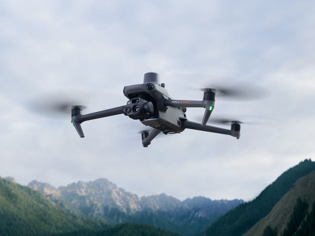
The DJI Mavic 3 Enterprise is designed to be both compact and extremely efficient, making it ideal for fast, accurate mapping missions. This model features a Hasselblad camera with a 4/3-inch CMOS sensor capable of capturing high-resolution aerial images. Its portability in no way detracts from its performance, as it offers up to 45 minutes flight time thanks to its optimized battery, and a transmission range of up to 15 kilometers. The Mavic 3 Enterprise is also equipped with multiple obstacle-avoidance sensors, ensuring safe flight even in dense forest areas.
The DJI Matrice 350 RTK
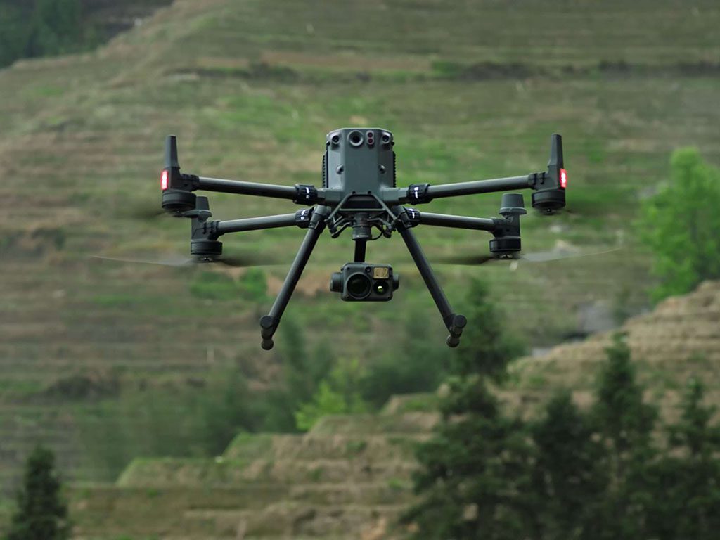
The DJI Matrice 350 RTK is renowned for its robustness and ability to handle multiple payloads. This drone is particularly popular for high-precision applications such as topographical surveys. It can fly for up to 55 minutes, covering large areas in a single flight. The Matrice 350 RTK is equipped with RTK (Real Time Kinematics) technology, enabling it to fly with centimetric precision. It is also able to withstand strong winds and temperatures ranging from -20 to 50 degrees Celsius, making it suitable for the harsh conditions often encountered in forestry.
The Wingtra ONE GEN II
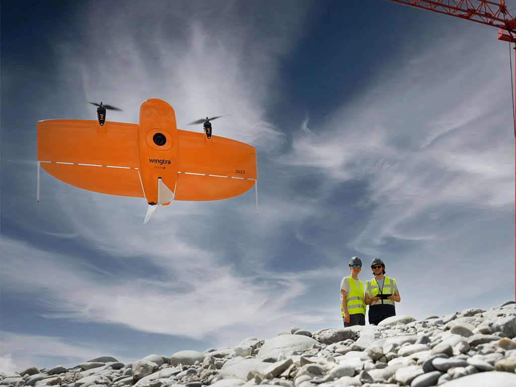
The Wingtra ONE GEN II is distinguished by its ability to perform vertical take-off and landing (VTOL) flights, which is ideal for operating in forested areas where terrain may be rough and impassable for horizontal take-offs and landings. This drone is specially designed for high-precision surveys over large areas. It is equipped with a 42 MP camera and can be configured with multispectral or LiDAR sensors according to specific project requirements. The Wingtra ONE can cover up to 1,500 hectares at a flight altitude of 120 meters per mission, making it an excellent choice for large-scale mapping and ecological monitoring projects.
Training and regulations governing the use of drones in forestry
The operation of drones in forestry is governed by specific regulations designed to ensure safety and respect for the environment. In Canada, for example, drone pilots must be certified by Transport Canada and comply with flight regulations, particularly in protected areas. The training of drone operators is also crucial to ensure that missions are carried out efficiently and safely, taking into account the specificity of forest environments.
In short, drones have become an indispensable tool for the forestry sector, bringing innovations that are transforming traditional practices and enabling more precise and sustainable forest management.